
1.5 KiB
Cartesian Coordinate System
A two-dimensional coordinate system in which every point is uniquely identified by a pair of signed distances to a pair of perpendicular lines.
!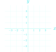 A Cartesian coordinate plane
The Cartesian coordinate system is a two-dimensional coordinate system that uniquely identifies each point in two-dimensional Euclidean space using an ordered pair of signed distances to an ordered pair of fixed perpendicular lines known as the axes.
The intersection of the two axes is known as the origin and is defined as .
Higher dimensions
The Cartesian coordinate system can be generalised to any -dimensional Euclidean space.
In an -dimensional Euclidean space, points are specified with an ordered set of signed distances to an ordered set of fixed perpendicular dimension hyperplanes instead.
!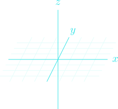 The Cartesian coordinate system in three dimensions with the - Cartesian coordinate plane embedded
Notation
In two-dimensional Cartesian coordinates, the horizontal and vertical axis are often denoted as the -axis and the -axis, respectively. Extending into three dimensions, the third axis is often denoted the -axis.
The coordinates themselves are referred to, in order, as the , , and coordinates. The and coordinates may also be referred to as the abscissa and the ordinate, respectively. Generic coordinates are thus notated as or .
The axes and coordinates may also be denoted using subscripts, as in , which is extendable to any -dimensions.